The Pacific is sending a stronger warning, but it is not a timetable for a disaster at your address. In its October 8, 2026 ENSO discussion, NOAA's Climate Prediction Center says El Niño continues to strengthen and gives a greater-than-83% chance of strong-to-very-strong conditions through January–March 2027. That is a significant climate outlook. It is also different from saying that a particular town will flood, lose electricity or run out of water.
For readers trying to make sense of the phrase “super El Niño,” the immediate task is to separate three questions. What are scientists observing in the tropical Pacific? What do forecast models suggest for the coming seasons? And which decisions should a household make using local warnings? Those questions belong together, but their answers are not interchangeable. This source-linked news explainer was checked on October 9, 2026; the planning examples below are our editorial interpretation, not new weather predictions.
Watch: What is El Niño?
What NOAA announced on October 8
The October ENSO Diagnostic Discussion keeps an El Niño Advisory in effect and reports ocean warming alongside an atmospheric response. Its measurements concern specified Pacific monitoring regions. They are not the air-temperature increase forecast for the United States.
The next discussion is scheduled for November 12, 2026. When sharing a record claim, preserve the agency, index and season. A forecast of ocean-index strength is not a forecast of household damage. Checking a dated agency release is more useful than circulating an undated screenshot.
Why the phrase super El Niño needs context
“Super El Niño” is a headline description that can obscure the measurement underneath it. Before treating a record claim as settled, look for the agency, index, reference period and season. A weekly sea-surface anomaly, a monthly average and a three-month index can all describe the same developing event without having identical values. A record in one monitoring region should not silently become a record across the whole ocean.
The distinction matters because the word “super” encourages readers to imagine one uniform outcome. A strong event can change the odds of certain patterns, but the term does not tell a renter whether a basement is safe, a driver whether a road is open, or a farmer whether irrigation restrictions have begun. Those decisions need more specific information. Our practical reading rule is simple: keep the dramatic label beside the actual forecast, not in place of it.
What the international outlook adds
The World Meteorological Organization's September 3 statement describes an established event expected to intensify and a near-100% likelihood of persistence through February 2027. It also explicitly cautions that event strength alone does not determine the severity of effects in an individual region. Other ocean conditions and the season can alter the familiar pattern. This is the international background to the newer U.S. bulletin, not an October statement being presented with a changed date.
The agencies' probability figures should therefore not be placed in a competition. One may describe persistence, another a strength category, and another the chance of exceeding a historical index threshold. Before comparing them, ask whether the question and time window match. A household gains little from choosing the most frightening percentage. It gains more from identifying the relevant regional forecast and deciding what would make an ordinary disruption difficult to manage.
How a Pacific climate pattern reaches distant places
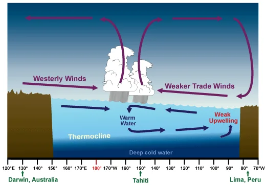
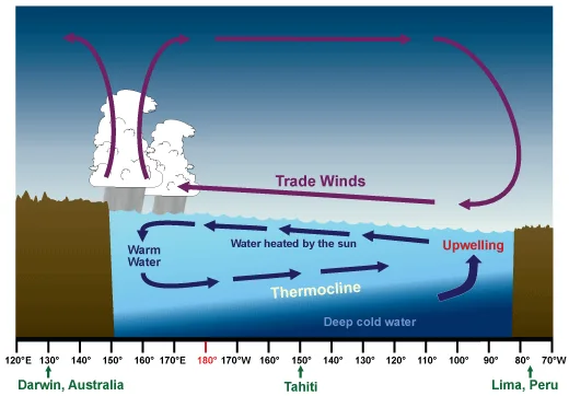
NOAA's ENSO explanation describes a linked ocean–atmosphere process involving Pacific warmth, changing trade winds and shifting tropical rainfall. The resulting circulation changes can influence the jet stream and weather far from the equator. That connection helps explain why a Pacific update attracts attention in North America and Europe. It does not mean every storm occurring during the event was caused by El Niño.
Think of the information as a change in the background conditions under which weather develops. A local forecast still needs to account for the actual atmosphere, approaching systems and terrain. Readers can use the seasonal outlook to bring forward sensible checks, then use short-range forecasts to decide when to travel or change plans. This two-step approach avoids both extremes: ignoring a meaningful outlook and treating a seasonal signal as a precise daily instruction.
What U.S. readers should watch this winter
The National Weather Service's ENSO overview describes a familiar winter tendency toward a more active southern storm track and milder conditions across the North. That is a historical pattern, not a promise for every state this year. The sensible question for a household is which local vulnerability could become important if the region experiences its expected pattern—and which hazards remain possible even when the seasonal average points elsewhere.
For a family whose main road has flooded before, the useful preparation may be agreeing on an alternate route and checking official closure information. For a household with electric heating, an outage plan remains relevant even in a broadly mild winter. Neither example is a forecast of a specific incident. They show how the same climate news can lead to different preparation tasks without buying a generic “super El Niño” package.
The Northwest has a different set of questions
The USDA Northwest Climate Hub explains that Idaho, Oregon and Washington often experience warmer, drier fall and winter conditions during El Niño. Alaska's pattern differs, including a tendency toward wetter falls. The hub also connects reduced snow and runoff with later water concerns. Its general explanation is useful, but an older forecast percentage embedded in that page should not replace the dated October NOAA update.
For readers, this means “less winter precipitation” should not be interpreted as “no dangerous weather.” A seasonal average can conceal individual wet periods. Likewise, the eventual water picture depends on observations collected over time, not just the label attached to the climate cycle. Our companion U.S. winter and Northwest explainer examines those regional distinctions and the kinds of local information worth following.
What this means for the UK and Western Europe
The Met Office's 2026 analysis discusses increased chances of wetter, stormier conditions in Northwest Europe during autumn and early winter. That is an agency interpretation for a particular part of the season. It should not become a blanket claim that every European country faces identical weather or that a specific storm has already been scheduled.
For readers outside the United States, follow the weather and emergency authorities serving your own country. A U.S. alert-radio recommendation may not provide the service you need elsewhere. Our editorial recommendation is to write down the local warning source, the authority issuing evacuation instructions and the place to check transport disruption. Doing that now makes the international story locally usable without pretending that a global news article can replace national guidance.
Why forecast confidence and local uncertainty can coexist
There is no contradiction between high confidence that the Pacific event will persist and uncertainty about what happens on a particular street. They are different questions. The first concerns a broad climate system; the second depends on a specific weather event meeting a particular landscape, drainage network, building and population. Combining those questions into one certainty makes the news less accurate and the preparation less useful.
Our suggested way to read a forecast is to label each statement: observed, forecast or action. “The agency measured an anomaly” belongs in the observed column. “The model favours a seasonal category” belongs in forecast. “Check your warning settings” belongs in action. This small separation helps prevent forecasts from turning into claims about completed disasters. It also makes later updates easier to assess because readers can see exactly which part changed.
Seasonal outlooks do not replace emergency warnings
The National Weather Service identifies Wireless Emergency Alerts and NOAA Weather Radio as ways to receive its warnings directly. A household should understand which channels it can actually receive and what happens if a phone is uncharged. Social posts can draw attention to an issue, but the official warning and its instructions remain the important information during an unfolding event.
A useful household exercise is to ask who receives alerts overnight, who checks on a dependent relative and who can explain the plan if the usual organiser is away. This is a planning exercise, not a claim that the local system will fail. Check accessibility as well: a warning that exists but cannot be heard, read or understood by the person who needs it is not an adequate personal arrangement. Adapt the plan to the actual users.
Water, electricity and food deserve separate plans
El Niño coverage often becomes one long shopping list. A better approach is to identify the service each household relies on and what its interruption would mean. Water storage, access to light, safe food and essential medicines are separate tasks. A fully charged phone does not solve drinking-water needs. A box of canned food does not provide a manual way to open it. A large kit may still leave one critical arrangement missing.
The CDC's emergency water guidance recommends at least one gallon per person per day for three days and, where possible, a longer reserve. Our El Niño preparedness checklist turns that and other official safety guidance into an organised household review. It includes optional product comparisons, but the checklist can be used without purchasing anything through our links.
Avoid turning climate headlines into panic purchases
Before spending, make an inventory. Our recommended format is item, quantity, location, person responsible and review date. It is deliberately ordinary. The aim is to discover whether a needed object is present, accessible and usable. A torch that works is more useful than another sealed package in a cupboard nobody checks. A known neighbour who can help with transport may resolve a problem that another gadget cannot.
Treat claims that one product will “protect you from super El Niño” with caution. The event is not a single hazard with one universal defence. Compare the product against the task: carrying water, opening food, receiving broadcasts or keeping paperwork together. We do not claim to have field-tested the products in this coverage. Buying through an affiliate link does not change what local weather is forecast or replace official safety instructions.
A practical way to follow updates without doomscrolling
Choose a small set of sources rather than trying to monitor every dramatic headline. Keep the dated ENSO bulletin for climate context, the regional seasonal outlook for broader planning and the local forecast or emergency alert for immediate action. Set a review time that fits your household. During an active warning, follow the issuing authority rather than waiting for your scheduled check.
When an update appears, record what materially changed. Did the probability concern persistence or intensity? Did the season change? Did a local authority issue a new instruction? A different headline alone is not necessarily a new practical development. This approach is our suggested information routine; it is not a forecast service. It can help readers remain informed while keeping time available for concrete preparation and ordinary life.
Questions readers should ask before sharing a claim
Does the post identify its source and publication date? Does “record” refer to a measured value or a forecast? Is the stated temperature an ocean anomaly or an air-temperature prediction? Is the map showing probabilities, expected amounts or observed conditions? Does a statement about the entire season get presented as a claim about next Tuesday? These are editorial checking questions, not an alternative scientific definition.
One additional question is worth asking: what action would the information change? If it supports checking a local warning channel, do that. If it supposedly demands an immediate expensive purchase but provides no local context, pause and verify. Share the agency's dated explanation where possible. A careful summary can still convey urgency; it simply attaches urgency to a useful decision instead of to an unsupported certainty.
What to do with this update today
Read the official forecast, identify your local warning source and complete one household task that would matter during an interruption. That could mean finding the torch, checking a cable, agreeing on a meeting place or asking a pharmacist about a medicine-storage contingency. Those examples are deliberately achievable. Preparation is easier to review when it produces a real arrangement rather than a growing list of hypothetical worries.
The October outlook warrants attention, and it may change as new observations arrive. It does not justify claiming that a named neighbourhood will experience a particular disaster. Use our complete checklist for the household work, and the regional explainer for winter context. For immediate hazards, official local warnings take priority over this article and over any social-media summary of it.