
The short answer
Storm surge is one cause of flooding. It raises coastal water and can move inland through low ground and connected waterways. Rainfall and river flooding can threaten different inland areas. Hurricane category measures wind, not total flood danger.
Can surge reach inland? · Category versus flood risk · Read the water levels
A hurricane can flood a coastal neighborhood while another community, far from the shoreline, faces rising river water. Calling both situations flooding is correct. Treating them as the same problem can lead to the wrong preparation, the wrong map or a dangerously late departure.
The useful comparison is **storm surge vs inland flooding**. Surge identifies a storm-driven rise in coastal water. Inland flooding commonly involves rain collecting faster than it can drain or rivers receiving more water than their channels can contain. The hazards can overlap, especially around tidal rivers, bays and low-lying drainage networks.
I would start a household plan with three questions: **Where could the water come from? Which official warning applies to this address? Can everyone leave before the route becomes unsafe?** A hurricane category answers none of those questions by itself. This guide explains the distinctions without pretending that a national explainer can forecast the depth at your front door.
Storm surge vs flooding at a glance
**Flooding means water covering land that is normally dry. Storm surge is one mechanism that can produce it.** Comparing surge with all flooding therefore compares one cause with the broader result. When people ask about the difference, they usually mean seawater pushed inland versus freshwater flooding from rainfall, runoff or rivers.
NOAA distinguishes a storm-driven rise above the predicted astronomical tide from **storm tide**, which combines that rise with the tide. Waves act on top of the elevated water and create additional hazards. Those terms describe different parts of the coastal-water problem, rather than three interchangeable forecasts. NOAA’s storm-surge explanation provides the underlying definitions.
| Feature | Storm surge | Inland rainfall or river flooding |
|---|---|---|
| Water source | Storm-driven coastal-water rise | Rain, runoff or water moving through a river basin |
| Possible setting | Coast, bays, estuaries and connected low areas | Urban drainage, streams, rivers, low ground and other inland settings |
| Information to check | Surge inundation products and local evacuation instructions | Local flood warnings, rainfall information and river forecasts |
| Category alone enough? | No | No |
| Can they overlap? | Yes, particularly around tidal waterways | Yes, rainfall and river flow may interact with elevated coastal water |
For planning, identify both the source and the consequence. A coastal evacuation zone addresses a different question from a damaged basement drain. A household beside a river may need a departure plan even when the beach is nowhere nearby. An apartment on a higher floor may still lose safe access, power or essential services.
The water’s appearance is not a reliable shortcut. Brown water is not automatically river water; clear-looking water is not automatically clean. Once flooding reaches buildings, roads and drainage systems, the source label alone cannot establish what the water contains or whether entering it is safe. CDC’s floodwater guidance explains the exposure risks.
What causes storm surge and why the coastline matters
Strong onshore winds can drive coastal water toward land. The resulting rise depends on more than the hurricane’s highest wind speed. Storm size, approach, forward motion, coastal shape and the underwater slope all influence the outcome. A wide, shallow coastal area behaves differently from a steep offshore shelf. NHC’s storm-surge overview explains those contributing factors.
Think about a bay, canal or estuary as part of the coastal system, not a barrier separating the coast from inland. The practical question is whether elevated coastal water can reach the area through connected waterways and low ground. A road between your house and the beach does not prove protection.
A statement such as “we are several miles from the ocean” is incomplete. It omits elevation, connected channels, the forecast and the route out. The address may be outside an evacuation zone, inside one, or dependent on a low road that crosses a vulnerable area. Those are local-map questions.
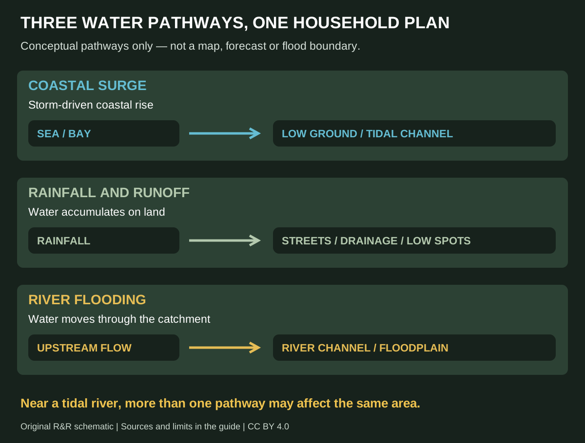
Use the schematic to identify questions for local authorities, not to estimate your water level. It contains no predicted boundary or safe-distance line. A diagram that invents a flood extent would be less useful than an honest explanation of which official product you need.
Can storm surge happen inland?
**Yes. Storm surge can move inland along low-lying ground and through connected rivers and canals.** Inland is not a fixed safety distance. The reach varies with terrain, waterways and the particular storm. NWS notes that surge can travel several miles inland in its hurricane-awareness guidance.
But not every flood away from the coast is storm surge. Rainfall flooding may occur much farther from the shoreline, including places with no tidal connection. If water is entering an inland basement after prolonged rain, the useful investigation may concern groundwater, foundation drainage, a sump or a sewer—not an ocean surge.
Three hypothetical households show the distinction. A home beside a tidal canal needs to check coastal inundation and evacuation information. A home beside an inland river needs its river forecast and local flood instructions. A home with no nearby open water may still have drainage or groundwater problems during heavy rain. These are planning examples, not assessments of named properties.
For water already appearing inside a basement, use our guide to water coming up through the basement floor after heavy rain. It separates observed entry routes before discussing equipment or repairs. Do not diagnose the cause from the storm’s name.
Inland flooding can continue after the wind eases
Heavy rain can overwhelm local drainage, produce rapid flash flooding or move through a river basin over a longer period. Water falling upstream matters even when rainfall at your house has slowed. NWS describes these mechanisms in its flood-hazards overview.
For a household, the important difference is timing. A departure decision cannot depend only on what the sky looks like outside the window. Check the official information for the river, road and neighborhood involved. The hurricane moving away and the route becoming safe again are separate findings.
Keep the monitoring task specific. Write down which local warning page to check, who will check it and how the rest of the household will receive the decision. A vague instruction to watch the weather leaves too much unresolved when power, mobile data or attention is limited.
If the outage affects a basement pump, read what to do when a sump pump stops during a power outage. A working sump addresses a particular collection system; it does not make a building safe against moving exterior floodwater or coastal inundation.
Hurricane category is a wind rating, not a flood-risk rating
The Saffir–Simpson Hurricane Wind Scale classifies hurricanes by sustained wind. It does not combine storm surge, rainfall flooding and tornado hazards into one overall danger score. NOAA warns against using the category as the whole forecast in its forecast-information guide.
This changes how to read a downgrade. A lower wind category does not itself establish that an evacuation order has changed, a tidal river is safe or the inland rain threat has ended. Look for the updated hazard information and instructions, rather than translating the category into your own flood-clearance decision.
Separate your notes into four lines: wind, coastal water, inland water and access. Beside each, record the official source or instruction relevant to your location. This organization prevents a reassuring update about one hazard from erasing an unresolved problem in another.
Florence shows why Category 1 does not mean minor flooding
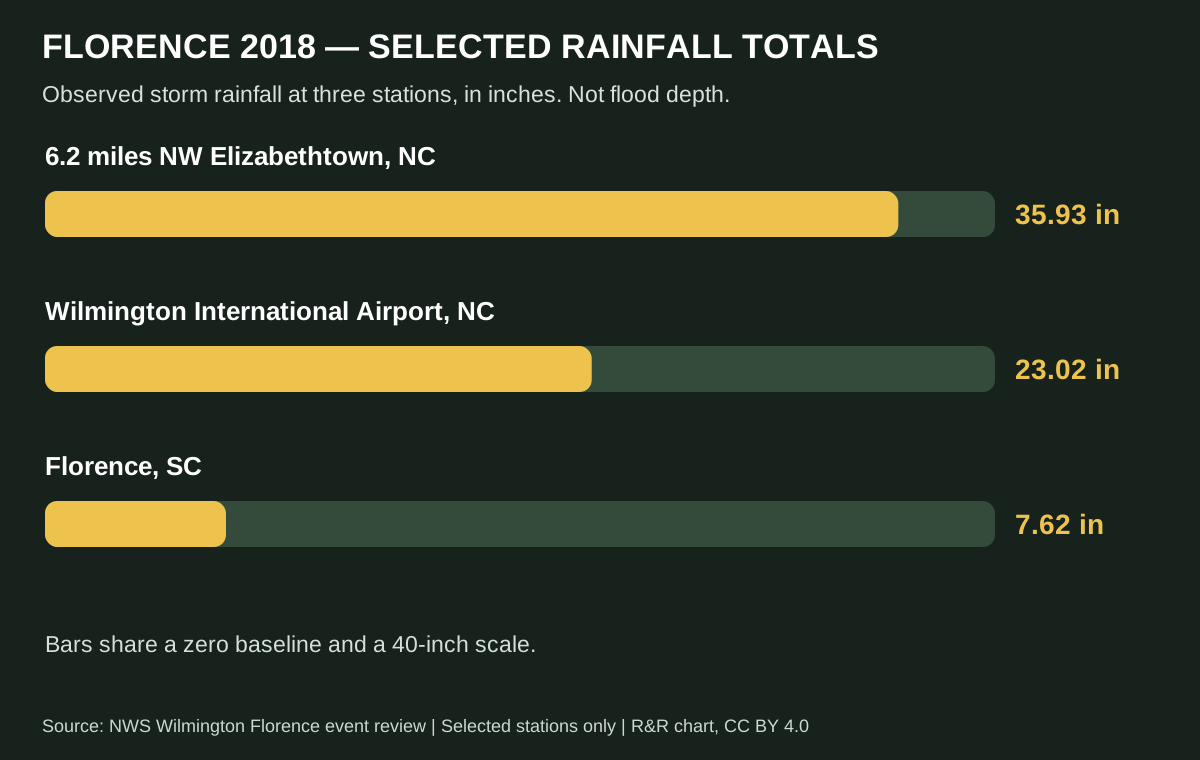
Hurricane Florence made landfall near Wrightsville Beach, North Carolina, on September 14, 2018, as a Category 1 hurricane. NWS Wilmington documents exceptional rainfall and subsequent river flooding. Its station table includes **35.93 inches northwest of Elizabethtown**, **23.02 inches at Wilmington International Airport** and **7.62 inches at Florence, South Carolina**. Read the verified NWS event review.
| Selected NWS station | Storm rainfall (inches) |
|---|---|
| 6.2 miles NW Elizabethtown, NC | 35.93 |
| Wilmington International Airport, NC | 23.02 |
| Florence, SC | 7.62 |
Download chart data (CSV) · Primary NWS event review
These selected observations illustrate geographic variation within one historical storm. They are not a current forecast, a representative sample of every community or a direct measure of flood depth. The comparison supports one narrow conclusion: the wind category alone did not describe Florence’s rainfall consequences.
Storm surge and heavy rain can create a combined problem
Near the coast, a household may face several water pathways during the same event. Coastal water can rise while rain adds runoff and rivers carry water downstream. This overlap is often called **compound flooding**. Research archived by NOAA examines how these processes interact in the Sabine–Neches Estuary. It does not provide a forecast for your address.
For planning purposes, ask whether the coastal-water forecast and the rainfall or river forecast describe different parts of the same neighborhood’s risk. Do not add two published numbers together unless the issuing agency explains that calculation. Different maps may use different reference levels, times and assumptions.
Consider a fictional family whose home is above the first low street in the neighborhood. Their house elevation does not answer whether the street remains usable. Their plan needs an early departure trigger and an alternative destination, rather than a promise to leave only if water reaches the doorway.
Our El Niño flooding and regional-risk guide addresses broader seasonal context. A seasonal pattern is not an address-specific storm forecast. Use current hazard information for an actual event, whether or not a seasonal outlook suggested a wetter or quieter period.
Read flood heights without mixing the reference levels
Before interpreting a flood number, ask **above what?** Above-ground inundation, water level relative to a tidal datum and storm-driven rise above the predicted tide are different measurements. Identical numbers with different reference points do not describe identical conditions at a house.
NHC’s Potential Storm Surge Flooding Map describes possible surge inundation above ground and accounts for forecast uncertainty. It is not a map of every freshwater-flooded road. Read its explanation and the separate rainfall and river products before using it to plan a journey.
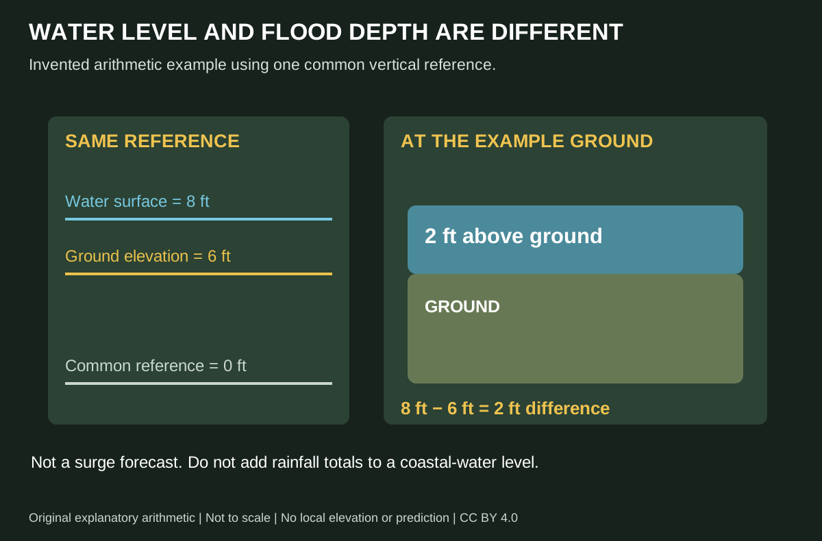
The arithmetic example uses an invented common reference: a water surface at eight feet and ground at six feet produces a two-foot difference. It is not a forecast or a method for calculating your own inundation from a general coastal headline. Real forecasts require the correct local ground information, datum and product interpretation.
Keep a copy of the map legend with a saved map. A cropped social image without its date, units or reference level can remove the information needed to interpret it. When sharing a forecast with relatives, send the official page and timestamp instead of only a screenshot of a color.
Which warnings and maps should a household check?
Start with your local emergency-management instructions and the official weather forecast for the address. Then check the products matching the possible water source: coastal surge, flash flooding or river flooding. The hurricane track is useful context; it is not the full boundary of damaging weather.
For U.S. readers, NHC hurricane information and NWS local forecasts and warnings are the starting points. Read the issued text as well as the graphic. A map’s color can help locate a hazard, but the accompanying instruction explains the action and area involved.
If you are visiting, ask which evacuation zone applies to the accommodation and who manages the departure decision. If you rent, ask how management communicates closures and re-entry instructions. Put a telephone number and an offline meeting arrangement beside the web links so the plan still works when someone cannot open a page.
Current reporting and historical examples serve different purposes
NOAA’s October 8, 2026, satellite coverage of Hurricane Isaias identified surge, strong winds and heavy rainfall as distinct expected hazards. That dated report helps explain the multi-hazard message; it is not a live warning on the day you read this guide.
Our Isaias flooding and power-outage coverage links the response information used in that article. Alabama EMA’s October 10 situation update also shows why restoring electricity and reopening transport need their own updates. Check newer local information before acting on an archived report.
Prepare for the decision to leave, not just the water
The most useful household record puts the next decision on one page. Include the address, relevant zone, destination, route, transport, medication arrangements, pet plan and the person responsible for checking instructions. Record what remains unknown. A blank that someone must resolve is more useful than an assumed answer.
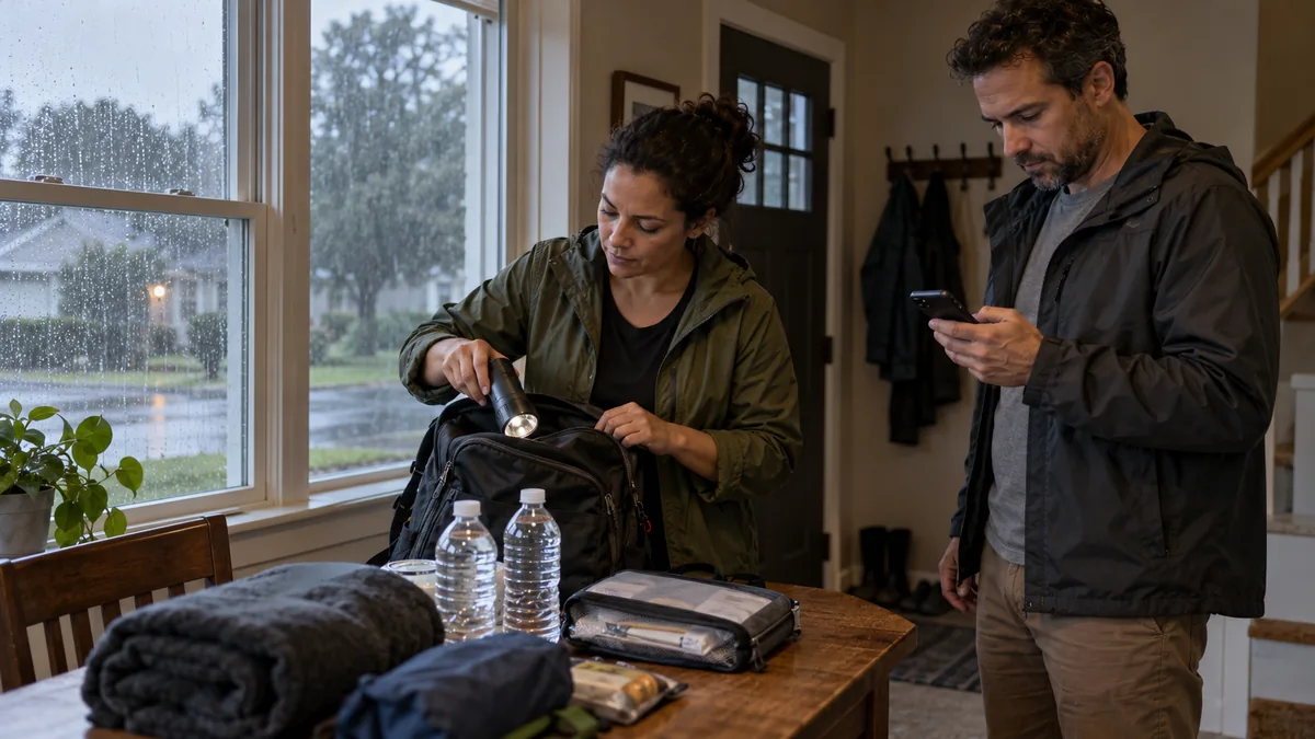
Rehearse the practical parts before conditions deteriorate. Can the person who needs medication find it? Can everyone carry their essentials or obtain help? Does the destination accept pets? Is there a way to contact a relative if the usual mobile-data connection fails? Buying another gadget will not settle these coordination questions.
Use the bug out bag checklist with its editable Excel inventory to track actual packed items. Families can use our family bug out bag guide to divide responsibilities without assigning a child equipment they cannot manage. The 72-hour household guide covers supplies kept at home.
For physical home preparation, use the El Niño household preparedness checklist and adapt the maintenance tasks to local conditions. Clearing a routine drainage issue beforehand and obeying an evacuation instruction are different jobs. Do not let unfinished property protection become a reason to miss a safe departure window.
Two useful products for alerts and a departure kit
You do not need to buy these products to use this guide. Their role is communication and hands-free lighting in an otherwise safe setting. Neither prevents inundation, makes a flooded road passable or replaces an evacuation instruction.
Use the equipment before relying on it
Set up a radio where broadcasts can actually be received and learn how its controls work. Keep more than one way to receive official instructions. A phone, a radio and a household contact plan cover different dependencies; none guarantees every message will arrive in every building.
Check the headlamp’s charge and controls while the room is dry and well lit. Pack charging accessories with the equipment rather than in a different drawer. A water-resistance rating is not permission to enter floodwater or handle equipment exposed to hazardous conditions.
For a broader power-system purchase, separate the household loads from the immediate departure kit. Our power-station review and compatibility discussion explains why stored energy and ability to operate a particular appliance are different questions. Do not buy a power station assuming it resolves every pumping or building-safety problem.
What to do if water is already approaching or entering
Follow emergency instructions and keep away from flooded routes. Do not wait to decide whether moving water is surge or just rain before taking the threat seriously. The distinction helps planning; it is not a reason to inspect a hazardous street, basement or canal.
NWS’s Turn Around Don’t Drown guidance warns against walking or driving into floodwater. Do not use another person’s vehicle crossing as your test. Your route decision needs current official information, not a guess about the depth from a photograph.
If an apartment is affected, use what to do when your apartment floods to organize safe observations, building notices and possessions records. If wastewater is backing up, use the sewage-backup response guide. Report what you observed without claiming to have diagnosed the water source.
Do not turn shopping into an emergency response. A pump purchase is not permission to enter standing water. Once immediate danger is controlled, our sump-pump buying guide can help compare permanent systems for an assessed basement need.
Recovery starts with access, utilities and materials
The end of rainfall is not a re-entry clearance. Ask who has assessed access, electricity, the structure and building services. Keep drinking-water notices separate from the fact that a tap runs. Keep wastewater availability separate from the fact that a toilet tank contains water.
If your utility has lifted a boil-water advisory, use our guide to the next household steps alongside the actual notice. For food, use the power-outage food-safety guide and its official food-specific references rather than deciding by smell.
For the building, read how to dry out a flooded house and how to prevent mold after a flood. The first organizes drying decisions; the second addresses affected materials and moisture. Keep photos and written instructions together, while letting qualified people resolve conditions a household record cannot certify.
Questions about storm surge and inland flooding
Is storm surge the same thing as a flood?
Storm surge is a storm-driven coastal-water rise that can cause flooding. Flooding is the broader result. Rainfall, rivers, drainage problems and other mechanisms can also cover normally dry land with water.
Can storm surge reach a house away from the beach?
Yes, depending on low ground and connected waterways. There is no universal distance that proves safety. Check official inundation information, evacuation zones and routes for the location instead of using miles from the shoreline alone.
Does a Category 1 hurricane have a low flood risk?
The category does not classify flood risk. It describes wind. Read the separate surge, rainfall and river information. Florence’s 2018 rainfall provides a verified example of why that separation matters, not a prediction of what every Category 1 storm will do.
Can I work out flood depth by adding surge and rainfall totals?
No. Rainfall depth, coastal water level and inundation above ground describe different things. Adding them without a valid hydrologic and reference-level explanation produces a misleading number. Use the issuing agency’s actual product and local instructions.
Is a house safe if the surge map does not shade it?
A surge product does not establish freedom from rainfall, river or drainage flooding. It also does not confirm that every route stays open. Read the product limits and check other hazards affecting the address.
Will a sump pump protect a house from storm surge?
A sump system manages water collected through its designed arrangement. Do not treat it as protection against exterior coastal inundation. Address the local evacuation and flood plan first; discuss a permanent drainage system separately with a qualified installer.
What is the most useful thing to do after reading this?
Find the correct local warning and evacuation information for your address, then confirm the departure arrangement with the household. Write down the unresolved question and who will answer it. Use the diagrams to understand the terms, not as a substitute for the local forecast.
Research method and reusable visuals
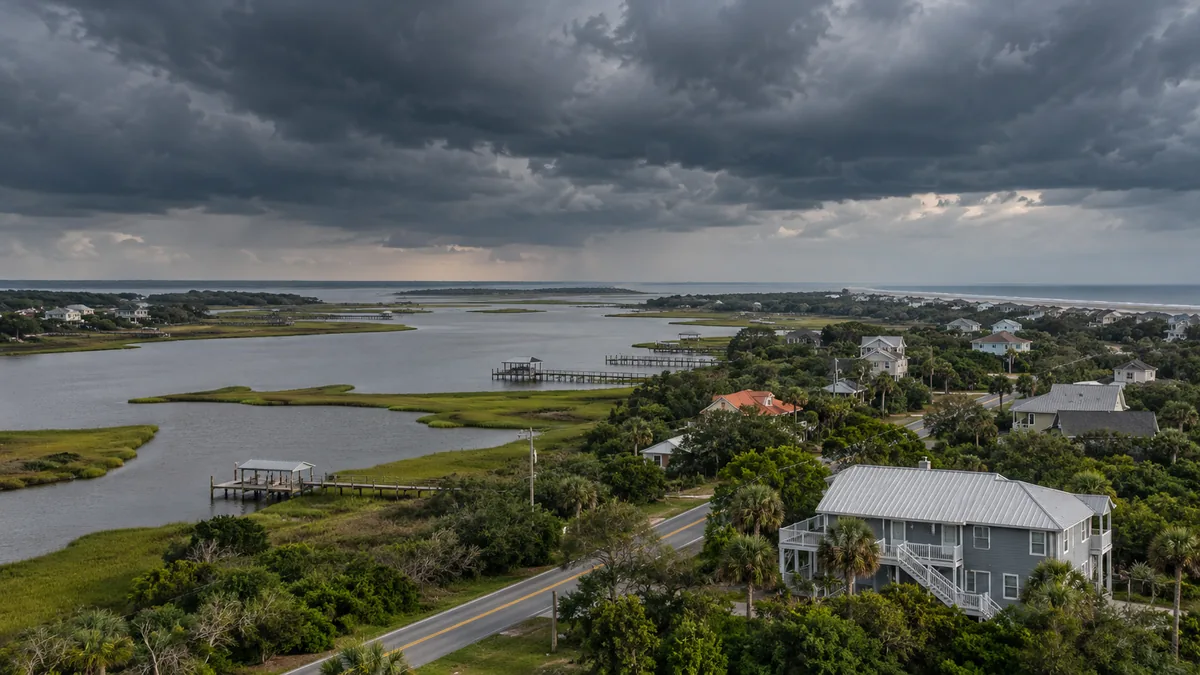
Ready & Resourceful prepared this explainer from linked NOAA, NHC, NWS and emergency-management references, checked October 20, 2026. It is an explanatory guide, not live storm reporting, a property assessment or independent professional safety review. The photographs are fictional planning scenes and do not depict Florence, Isaias or a documented field visit.
The original water-path schematic, reference-level example and Florence station chart may be reused with attribution under CC BY 4.0. That permission excludes photographs, product images and third-party material. The chart preserves selected NWS station labels and units; the reference-level graphic uses explicitly invented values. See our research and corrections policy if you find a factual issue.